Saving Seafood

  • Home
  • News
    • Alerts
    • Conservation & Environment
    • Council Actions
    • Economic Impact
    • Enforcement
    • International & Trade
    • Law
    • Management & Regulation
    • Regulations
    • Nutrition
    • Opinion
    • Other News
    • Safety
    • Science
    • State and Local
  • News by Region
    • New England
    • Mid-Atlantic
    • South Atlantic
    • Gulf of Mexico
    • Pacific
    • North Pacific
    • Western Pacific
  • About
    • Contact Us
    • Fishing Terms Glossary

New Poll the Latest Salvo in Fight Over a Marine National Monument for New England

July 14, 2016 โ€” A new poll finds that eighty percent of Massachusetts residents favor protecting special ocean areas from activities like mining and fishing. A coalition pushing President Obama to create a marine national monument in New England waters say this is one more measure of support. But opponents say the poll was misleading and biased.

The National Coalition for Fishing Communities has criticized the poll, calling it misleading. They say the way the poll was constructed led people into saying yes. Also, they argue economic impacts on fisheries were down-played, and alternative ways of achieving conservation goals โ€“ besides a marine monument โ€“ were omitted.

โ€œThis isnโ€™t an issue of do you believe or do you not believe important natural assets should be protected,โ€ said Bob Vanasse, Executive Director of Saving Seafood. โ€œItโ€™s a question of how they should be protected, what should be allowed in those areas, and should there be a fair public process using existing law to do that.โ€

The fishing industry has maintained that theyโ€™re not opposed to protecting important areas, but that those protections should come out of a transparent public process. The pro-monument coalition counters that the fishery management process doesnโ€™t provide adequate protection, and the federal legislature is unlikely to act. That leaves executive action as the only feasible option, they say.

Read the full story at WCAI

New Atlantic Marine Monument Poll Presents Misleading Picture of the Issues

July 12, 2016 (NCFC) โ€” Yesterday, a poll released by the Protect New Englandโ€™s Ocean Treasures Coalition claimed that 80 percent of Massachusetts and Rhode Island residents support national monument designation for certain ocean areas. However, the survey questions selectively presented information to respondents, withholding information about existing protections in the proposed monument areas.

The poll, conducted by Edge Research, a suburban Washington, DC polling company with a specialty in ocean conservation issues, consisted of phone interviews with 400 residents in Massachusetts and 403 residents in Rhode Island. Respondents were presented with questions that minimized the economic impacts of a potential marine monument.

When asked about the monuments, respondents were told, โ€œprotecting these areas would prohibit the fishing activity in these limited areas and could result in a small adverse economic impact on commercial fishing.โ€ [emphasis added]

But according to fishermen themselves, the economic impact of a marine monument could in fact be devastating โ€“ potentially costing the industry millions of dollars and thousands of jobs. The affected areas are important grounds for the valuable red crab, swordfish, tuna, and offshore lobster fisheries. This has led the affected fisheries, as well as virtually the entire New England fishing industry and its regulatory bodies, to unite in opposition to the current monument proposals.

The pollsters also repeatedly asked whether respondents supported federal protections for the areas in question, without mentioning the protections already in place under the current management system. These protections include the prohibition of federally managed fisheries from using bottom-tending gear in Cashes Ledge, one of the areas under consideration.

Several leading fisheries management bodies have made it clear that they support the current public and transparent process for habitat and fisheries management. The Atlantic States Marine Fisheries Commission passed a resolution in May asserting its preference for using the current process, under the Magnuson-Stevens Act, to develop protections for the proposed monument areas.

Also in May, the Council Coordination Committee, comprised of all eight regional fishery management councils in the U.S., stated its support for the โ€œpublic, transparent, science-based process and managementโ€ of fisheries required by the Magnuson-Stevens Act, the primary law governing fisheries management in the country. Marine protections enacted under this process are not mentioned as a potential alternative in the poll.

The press release accompanying the poll states that Edge Research โ€œis recognized as the chief pollster for ocean issues.โ€

The Edge Research principal named in the release, Lisa Dropkin, is described as having โ€œconducted research for a host of conservation organizations, including The Ocean Conservancy, Monterey Bay Aquarium, Environmental Defense Fund, and World Wildlife Fund.โ€ She also chairs Green Media Toolshed, โ€œan application service provider supporting media communications for environmental organizations,โ€ which lists among its goals strengthening the โ€œability of conservation groups to influence national, regional and local media.โ€

In June 2015, Edge Research โ€œpartnered with the David & Lucile Packard Foundation to conduct new research on American Millennialsโ€™ attitudes towards oceans, ocean conservation, and pathways for engaging this next generation of ocean leaders.โ€

There is no indication on the Edge Research website that they have ever done work for the commercial fishing or maritime shipping industries.

The Protect New Englandโ€™s Ocean Treasures Coalition, which is advocating for a Marine National Monument in the North Atlantic Ocean, is composed of Center for American Progress, Conservation Law Foundation, Earthjustice, Environment America, Mystic Aquarium, National Geographic Society, National Wildlife Federation, Natural Resources Defense Council, New England Aquarium, Ocean Conservancy, Oceana, and The Pew Charitable Trusts.

About the NCFC 
The National Coalition for Fishing Communities provides a national voice and a consistent, reliable presence for fisheries in the nationโ€™s capital and in national media. Comprised of fishing organizations, associations, and businesses from around the country, the NCFC helps ensure sound fisheries policies by integrating community needs with conservation values, leading with the best science, and connecting coalition members to issues and events of importance.

Environmental groups release scientific analysis of areas proposed for Atlantic marine monuments

March 29, 2016 โ€“ WASHINGTON (Saving Seafood) โ€“ This morning, the โ€œProtect New Englandโ€™s Ocean Treasures Coalitionโ€ released an analysis of Northeast ocean areas under consideration for designation as marine National Monuments. The analysis was conducted by Dr. Peter Auster of Mystic Aquarium and Dr. Scott Kraus of the New England Aquarium, and was presented in a press webinar organized by the Pew Charitable Trusts.

Dr. Auster and Dr. Kraus concluded, among other findings, that the proposed monument areas possess high habitat diversity and an abundance of species, function as a source of habitats including for commercial species, and contain species sensitive to disturbance. However, they noted that they do not have adequate data to address what the economic and human effects of area closures to fisheries might be. Presenters also acknowledged that the areas under consideration are already protected, but expressed concern about the future possibility of drilling and mining.

A monument designation would likely affect the fisheries for Atlantic red crab, offshore lobster, squid, mackerel, butterfish, tilefish, albacore wahoo, dolphinfish (mahi mahi), and others. Pelagic longline, rod and reel, and greenstick fisheries including yellowfin tuna, bluefin tuna, bigeye tuna, and swordfish may also be affected. During the webinar, the presenters conceded that they do not have enough data to analyze how a monument designation would affect many of these fisheries.

The analysis addressed both Cashes Ledge and the Northeast Seamounts and Canyons. White House officials stated last week that Cashes Ledge is โ€œnot under consideration for a [national monument] designation at this time.โ€ However, representatives of the Northeast Seafood Coalition and Associated Fisheries of Maine, who attended meetings with White House officials, said in a joint statement that offshore canyon areas east of Cape Cod remain under consideration and โ€œaffected fishermen should remain vigilant in assuring that any concerns they may have are addressed.โ€

The Protect New Englandโ€™s Ocean Treasures Coalition, which โ€œis advocating for the establishment of a Marine National Monument in the North Atlantic Ocean,โ€ is composed of:

  • Center for American Progress
  • Conservation Law Foundation
  • Environment America
  • Mystic Aquarium
  • National Geographic Society
  • National Wildlife Federation
  • Natural Resources Defense Council
  • New England Aquarium
  • Ocean Conservancy
  • Oceana
  • The Pew Charitable Trusts

Read a fact sheet about the proposed Atlantic monument areas

Captions courtesy of Pew Charitable Trusts

Proposed NE monument

Proposed Marine National Monument in Northeastern Waters of the U.S.

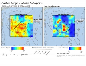
These maps illustrate that while whale and dolphin species are distributed throughout the whole Cashes Ledge region, the deep water toward the center of the proposed monument area is a hot spot for both the total numbers of species (left) and the total numbers of animals (right). Courtesy of Scott Kraus and Brooke Wikgren, New England Aquarium

These maps illustrate that while whale and dolphin species are distributed throughout the whole Cashes Ledge region, the deep water toward the center of the proposed monument area is a hot spot for both the total numbers of species (left) and the total numbers of animals (right). Courtesy of Scott Kraus and Brooke Wikgren, New England Aquarium

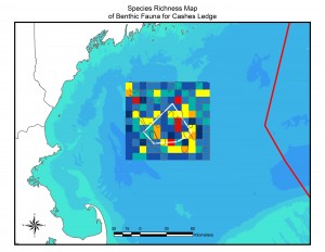
This map illustrates the pattern of species richness (number of species) of bottom-dwelling animals in the Cashes Ledge area. Warmer colors indicate more species. The largest red diversity hot spot is the peak of Cashes Ledge, where the largest continuous kelp forest on Cashes Ledge is located. Note that this map displays number of species, not numbers of individuals or density of animals. Courtesy of Peter Auster and Michel McKee, Mystic Aquarium

This map illustrates the pattern of species richness (number of species) of bottom-dwelling animals in the Cashes Ledge area. Warmer colors indicate more species. The largest red diversity hot spot is the peak of Cashes Ledge, where the largest continuous kelp forest on Cashes Ledge is located. Note that this map displays number of species, not numbers of individuals or density of animals. Courtesy of Peter Auster and Michel McKee, Mystic Aquarium

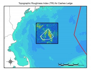
Topographic roughness โ€“ essentially, small-scale bumpiness of the seafloor โ€“ is linked to the distribution and diversity of microhabitats that in turn support a diversity of species. Warmer colors indicate greater "roughness" and are linked to locations of species-rich communities. For example, the area of high roughness on the top of Cashes Ledge (right inside the proposed monument boundary) is where the kelp forest is located and a species diversity hotspot. Courtesy of Peter Auster and Michel McKee, Mystic Aquarium

Topographic roughness โ€“ essentially, small-scale bumpiness of the seafloor โ€“ is linked to the distribution and diversity of microhabitats that in turn support a diversity of species. Warmer colors indicate greater โ€œroughnessโ€ and are linked to locations of species-rich communities. For example, the area of high roughness on the top of Cashes Ledge (right inside the proposed monument boundary) is where the kelp forest is located and a species diversity hotspot. Courtesy of Peter Auster and Michel McKee, Mystic Aquarium

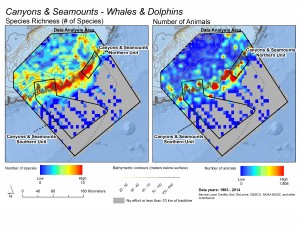
These maps illustrate patterns in the richness of species (left) and total numbers of whales and dolphins (right) observed during surveys in the Northeast Canyons and Seamounts region. Warmer colors indicate greater richness or abundance. Note how species concentrate on the eastern Georges Bank, where the shelf descends into the deep ocean, and hot spots for concentrations of whales and dolphins dot the shelf-edge. Courtesy of Scott Kraus and Brooke Wikgren, New England Aquarium

These maps illustrate patterns in the richness of species (left) and total numbers of whales and dolphins (right) observed during surveys in the Northeast Canyons and Seamounts region. Warmer colors indicate greater richness or abundance. Note how species concentrate on the eastern Georges Bank, where the shelf descends into the deep ocean, and hot spots for concentrations of whales and dolphins dot the shelf-edge. Courtesy of Scott Kraus and Brooke Wikgren, New England Aquarium

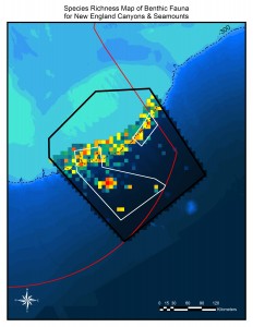
This map shows hot and cold spots for species of bottom-dwelling animals in the New England Canyons and Seamounts areas. Species are especially diverse along the edge of Georges Bank, where the shelf descends into the deep ocean. Hot spots are also visible on Bear, Physalia, Retriever and Mytilus Seamounts. Courtesy of Peter Auster and Michel McKee, Mystic Aquarium

This map shows hot and cold spots for species of bottom-dwelling animals in the New England Canyons and Seamounts areas. Species are especially diverse along the edge of Georges Bank, where the shelf descends into the deep ocean. Hot spots are also visible on Bear, Physalia, Retriever and Mytilus Seamounts. Courtesy of Peter Auster and Michel McKee, Mystic Aquarium

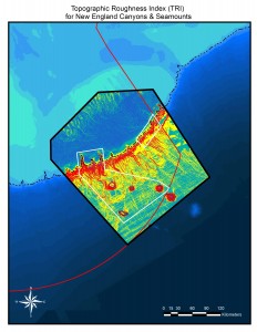
Topographic roughness โ€“ essentially small-scale bumpiness of the seafloor โ€“ is linked to the distribution and diversity of microhabitats that in turn support a diversity of species. Warmer colors indicate greater "roughness" and are linked to locations of species-rich communities. A high topographic roughness value suggests where especially rich communities may be found. The entire shelf-edge, where Georges Bank descends into the deep ocean, is topographically rough, and Bear, Physalia, Retriever and Mytilus Seamounts stand out. Courtesy of Peter Auster and Michel McKee, Mystic Aquarium

Topographic roughness โ€“ essentially small-scale bumpiness of the seafloor โ€“ is linked to the distribution and diversity of microhabitats that in turn support a diversity of species. Warmer colors indicate greater โ€œroughnessโ€ and are linked to locations of species-rich communities. A high topographic roughness value suggests where especially rich communities may be found. The entire shelf-edge, where Georges Bank descends into the deep ocean, is topographically rough, and Bear, Physalia, Retriever and Mytilus Seamounts stand out. Courtesy of Peter Auster and Michel McKee, Mystic Aquarium

Recent Headlines

  • Steen seeing hesitation from US buyers of processing machinery amid tariffs, cost uncertainties
  • Fishing fleets and deep sea miners converge in the Pacific
  • Local scientists, fisheries and weather forecasters feeling impact of NOAA cuts
  • Virginia and East coast fishery managers remain vigilant over status of Atlantic striped bass
  • Trump reinstating commercial fishing in northeast marine monument
  • Natural toxin in ocean results in restrictions on Pacific sardine fishing off South Coast
  • Equinor says it could cancel New York offshore wind project over Trump order
  • US, China agreement on tariffs encourages some, but others arenโ€™t celebrating yet

Most Popular Topics

Alaska Aquaculture ASMFC Atlantic States Marine Fisheries Commission BOEM California China Climate change Coronavirus COVID-19 Donald Trump groundfish Gulf of Maine Gulf of Mexico Hawaii Illegal fishing IUU fishing Lobster Maine Massachusetts Mid-Atlantic National Marine Fisheries Service National Oceanic and Atmospheric Administration NEFMC New Bedford New England New England Fishery Management Council New Jersey New York NMFS NOAA NOAA Fisheries North Atlantic right whales North Carolina North Pacific offshore energy Offshore wind Pacific right whales Salmon South Atlantic Western Pacific Whales wind energy Wind Farms

Daily Updates & Alerts

Enter your email address to receive daily updates and alerts:
  • This field is for validation purposes and should be left unchanged.
Tweets by @savingseafood

Copyright ยฉ 2025 Saving Seafood ยท WordPress Web Design by Jessee Productions

Notifications